Preservation in Progress

Historic Seattle’s Blog

Archive for the ‘Guest Posts’ Category

Giving a New Life to a 1909 Schoolhouse

By Bassetti Architects

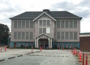
Located at the heart of the Beacon Hill neighborhood and designed by Seattle renowned architect Edgar Blaire, the Original Van Asselt School building was constructed in 1909 as one of the first elementary grade schools in south Seattle. Four classrooms organized around a central stair comprised the original two-story, wood-framed structure. The Original Van Asselt building has been described as a “free interpretation of the Tudor Style”, with a heavy timber porch and decorative half-timbering at the central gabled bay.

Subsequent major additions included the 1940s basement classroom additions and a 2002 elevator addition. Both additions were built to the west – what is viewed today as the back side of the building. In 1950, a sprawling, one-story mid-century modern high school with a flat roof and brick veneer siding was constructed adjacent to the original 1909 school, largely obstructing its view from Beacon Avenue S.

In 2019, 110 years after the school saw its first cohort of students, Seattle Public Schools hired Bassetti Architects to renovate the 1909 school building as part of a master plan to add capacity to the campus. This site was identified by Seattle Public Schools to be used as a swing site for several schools during their own renovation or replacement construction period.

Vacant and boarded up since 2016, the building was in disarray, but the design team could see its potential. In May 2019, the building was designated a City of Seattle Landmark, and both the exterior and interior of the original 1909 construction were considered significant contributing elements.

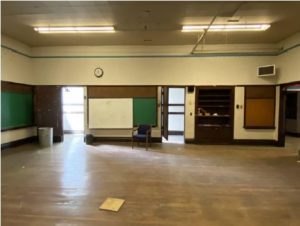
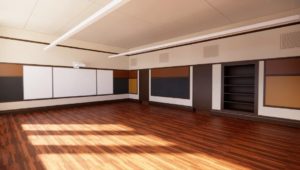
As part of the restoration, the classrooms will keep their original plaster walls and black slate chalkboards, while new mechanical, electrical, fire safety, and technology systems will be thoughtfully integrated to bring those spaces up to 21st century learning environment standards.

The main central stair will see its original plaster restored and the space will be brought up to code compliance on several fronts: the guardrail height will be increased while maintaining original elements, a new automatic sprinkler system will be installed, new light fixtures will be added, seismic upgrades will be completed, and fire separations will be provided. The building’s exterior wood and stucco siding will be repaired and painted, and its original wood window sashes and frames will be restored, reviving this community landmark’s historic character and integrity.

What is particularly unique about this project, is the successful revitalization of an abandoned centenary schoolhouse into a contemporary learning environment. Historic schoolhouses are often repurposed into apartments, museums, retails, or offices.

Because 21st century classrooms and other school resources require spaces and systems that are difficult to fit into smaller and older structures, the reuse of historic schoolhouses as modern teaching environments can be challenging. Thus, it’s no surprises that restoring the Van Asselt schoolhouse to its original purpose and protecting this part of Beacon Hill’s history while developing the site to best respond to the school district’s needs is an effort that was praised by the Seattle Landmarks Preservation Board, the School District staff, and the neighboring community alike. The schoolhouse’s new lease on life is an opportunity to make Original Van Asselt the shining jewel of the site once again and an integral part of the campus life.

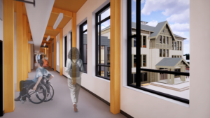
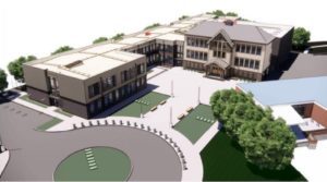
To accommodate the swing site capacity need, Bassetti designed a new two-story classroom and gymnasium addition to provide space for an additional 650 students on campus. This new structure is designed with sustainable structural system of Cross Laminated Timber (CLT) and will adjoin the Original Van Asselt school in a way that maintains the prominence of the original schoolhouse entry and provides a backdrop against which the landmark structure is featured. A formal courtyard, designed to accentuate the symmetry of the 1909 façade, further elevates the architecture and the neighborhood presence of the landmarked building.  

The color palette of the 1909 building was selected to accentuate the different architectural features while the exterior finishes of the new addition will complement the original schoolhouse, thus the buildings will read as a comprehensive composition within the larger campus. Bassetti focused on maintaining a level of simplicity in the design of the new addition. In doing so, the restored 1909 building is clearly established as the focal point of the site and remains the tallest and most ornate structure.

A true testament to the Landmark review process, the Original Van Asselt project is a shining example of a historic schoolhouse rehabilitation that will be celebrated and enjoyed by many more future generations of students, teachers, and community members.

Bassetti Architects is a generous sponsor of Historic Seattle’s 2022 Community Education & Advocacy Programming. This post is part of a series of guest blogs submitted by members of the Historic Seattle community.  The views and opinions expressed in guest posts are those of the authors and do not necessarily reflect the positions of Historic Seattle.

Photos:
1: 1909; 2: 1950; 3: 2022; 4: original classroom; 5: classroom remodel rendering; 6: hallway perspective; 7: site perspective (all courtesy of Bassetti Architects)

40 Years of Places: Parting Words from Cindy Hughes

Looking back over my 40 years with Historic Seattle, I find myself focusing on various sets of memories, from the many executive directors with whom I have worked (five in total), to the volunteer governance that I have supported (some of whose tenure with the organization goes back almost as far as mine), to the many properties acquired and restored by our real estate arm.

Somehow, it is the many and varied places where I have worked that rise to the surface when I reflect. Most who know the organization cannot picture us as being anywhere else than the Dearborn House, but there was much that went before.

I first joined the staff of HS when their offices were located on the 12th floor of the Smith Tower in Pioneer Square, at a time when our IBM Selectric typewriters represented the most advanced office technology of the day. My most recent workplace was my upstairs home office on Queen Anne Hill, working remotely during a global pandemic. In between?

There were stints in several Pioneer Square properties, both owned and rented, in the historic Dearborn House on First Hill when it was donated to us in the late 90s, as well as the Good Shepherd Center in Wallingford. All of these locations represented the organization recovering, growing, responding to opportunities, pivoting, and making the most of the unique set of powers it holds as a public development authority.

Through all these years and locations, I have been motivated and inspired by the mission of the organization. I always felt that I was part of a group accomplishing the valuable work of preserving places in Seattle that are important to all our residents. I look forward to watching this crucial and timely work continue even as I move onto my next chapter.

-Cindy Hughes, Council Assistant & Good Shepherd Center Rental Coordinator


Photo: Historic Seattle presented Cindy with the 2021 Preserving Historic Seattle Award at its Preservation Celebration in October.

Time to Save The Hahn Building, NOW

By Ruth Danner, President – Save the Market Entrance

The following is part of a series of guest blog posts submitted by members of the Historic Seattle community. The views and opinions expressed in guest posts are those of the authors and do not necessarily reflect the positions of Historic Seattle. As part of our mission, Historic Seattle is supporting Save the Market Entrance’s advocacy and communications work to landmark the Hahn Building.

With ground floor storefronts built in 1897 and two floors for workforce housing added in 1908, the Hahn Building/Hotel Elliott stands proudly at the southeast corner of Seattle’s intersection of First and Pike, at the main entrance to Pike Place Market. While Pike Place Market is a designated City of Seattle historic district (Pike Place Market Historical District) and listed in the National Register of Historic Places as the Pike Place Market Historic District, the historic buildings on the east side of First Avenue have been left to fend for themselves.

Its historic timeline goes back to the early 1880s arrival of Robert Hahn. In 1889, at the time of the Great Seattle Fire that devastated most of Pioneer Square, Hahn operated a wood-frame saloon and beer garden on this site. After the fire, it was said to be the last place standing for a man to buy a beer.  Following the fire, wood structures were out and brick was in, and in 1897, Hahn built the structure under nomination as a one-story, brick building.

A decade later, two stories were added to the existing structure just as Seattle prepared for the Alaska-Yukon-Pacific Exposition in 1909. Those two new floors were dubbed Hotel Elliott, which provided private semi-permanent housing for Seattle’s growing workforce, one of the first single-room-occupancy (SRO) hotels to offer private baths with running hot and cold water. The Hahn Building/Hotel Elliott is prominently featured in historic photos of the Market Entrance across the decades. Along with the Hotel Elliott, the ground floor has retail has hosted a number of commercial ventures—from long-time tenant Owl Drugs to the infamous International Donut Shop.

In the massive reinvigoration on Pike Place Market in the 70s, blacktopping on Pike Place from Pike to Virginia was returned to its former bricked cobblestones out to and including the intersection at 1st and Pike that tied the four corners of the Market together. In 1981, the Hahn family, perhaps inspired by the market’s facelift and newly returning popularity undertook a beautiful, historically sensitive remodel. Identifying Hotel Elliott as affordable housing, the City of Seattle allocated $500,000 to reinforce the structure with seismic retrofitting. Hotel rooms continue to occupy the upper two floors operating as the Green Tortoise Hostel since 2005.

Twice since the current owners purchased the Hahn in 1986, they have presented the Landmarks Preservation Board with anti-nominations designed to argue against historic significance in an effort to clear the way for future demolition (in 1999 and again in 2014). But the five-year limit in the Landmark Preservation Ordinance that precludes another nomination to be considered has passed (as of December 2019), and the door is open for the public to argue their own case for the importance this building plays to our city and beyond.

The Hahn Building is not currently protected, and the current owner has plans to demolish the Hahn building and replace it with a 14-story boutique hotel. On December 2, at 3:30 pm the Landmarks Preservation Board will meet to consider our nomination, which we submitted in December 2019. We hired Katie Pratt and Spencer Howard of NW Vernacular Historic Preservation to dig a little deeper into the Hahn’s history and importance at this important intersection. What they found is compelling. Preservation of this building is essential to the symmetry and historical authenticity to this treasured four corner Market entrance and intersection.

We need your help! Please send written comments in support of landmarking to Sarah Sodt, the City of Seattle Historic Preservation Officer, via sarah.sodt@seattle.gov by or before Tuesday, December 1.  Comments must relate to one or more of the six criteria for landmark nomination/designation. More information is available here.

Photo by Shree Ram Dahal

About Third Church

By Cindy Safronoff

The following is part of a series of guest blog posts submitted by members of the Historic Seattle community. The views and opinions expressed in guest posts are those of the authors and do not necessarily reflect the positions of Historic Seattle.

The classical revival style church edifice on Greek Row in the University District has been an important community gathering place for nearly a century.

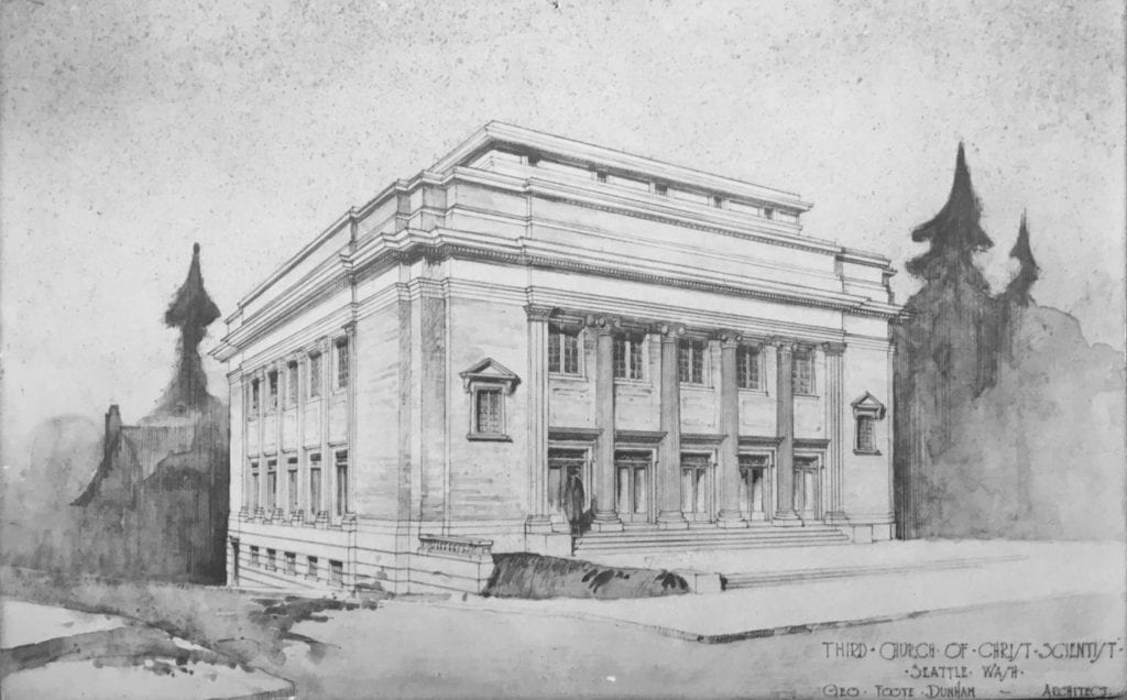
Architectural rendering of Third Church of Christ, Scientist, Seattle, by architect George Foote Dunham, 1919 (Third Church of Christ, Scientist, Seattle)


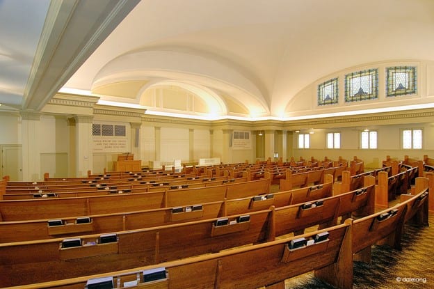
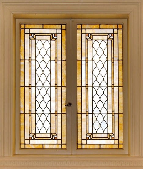
The edifice built by Third Church of Christ, Scientist, is twin sister to Fourth Church, now known as Town Hall Seattle. It was designed by the same architect in a similar style and layout and built by the same general contractor during the same time period. Although smaller overall, the auditorium has the same elegant curved ceilings, indirect lighting, and similar Povey Brothers windows with Dannenhoffer art glass. The decor of the auditorium was intended to express sunshine, sky, and clouds. The Greek motif was said to express the simplicity of truth.


Third Church of Christ, Scientist, Seattle, auditorium as it was when it was a Christian Science church (Photo: Dale Lang)


Lower auditorium stained glass windows (Photo: Dale Lang)


The building project was launched by Third Church of Christ, Scientist, the week of Easter 1919 as the Spanish Influenza pandemic was fading out. Shortly after the Building Committee selected George Foote Dunham to be their architect, he sent them a watercolor rendering to show the completed building. The painting hung in the Christian Science Reading Room in the University State Bank Building at 45th and University – where church services were being held at the time – to inspire their members to contribute to the building fund. It took three and a half years to complete the building, due to construction delays caused by funding problems. For an entire year, the site on Northeast 50th Street and 17th Avenue Northeast (then called “University Boulevard”) sat inactive with completed walls and roof but no windows or doors. Members took shifts standing watch at the building at night to protect it from vandalism. After completing financing for the project in early 1922, the building was completed within the year. Three overflowing opening services were held on Sunday, November 12, 1922.

The church edifice was officially dedicated seven years later. The Great Depression had begun, and – even before the economic collapse – Third Church had been struggling to pay off its overdue mortgage bond. After the infamous stock market crash on October 24, 1929, the other Christian Science churches contributed their next Sunday collections to the cash-strapped U-District congregation, enough to eliminate all their debt. Dedication services were held, again with three overflowing services, on Sunday, November 24, 1929.

The U-District congregation was youthful, which is perhaps unsurprising for a rapidly growing start-up church near a university. Most of the members of the Building Committee, which was representative of the overall membership at that time, were in their 30s. Christian Science then was one of the most popular religious preferences among University of Washington (UW) college students, especially among the female students. Two members of the Building Committee, Ruth Densmore and Helen Lantz, had recently graduated from the UW with graduate degrees and were married to UW professors.

In the early twentieth century, Christian Science offered a new religious alternative that empowered women. Founded in 1879 by a woman, Reverend Mary Baker Eddy, The First Church of Christ, Scientist, in Boston, recognized equality of the sexes, preached support of women’s rights, and normalized women as church service officiants. Around 90% of Christian Science practitioners, the closest equivalent to clergy or ministers, were women. In the history of Christian Science in Seattle, women played a prominent founding role. Christian Science was planted in Seattle in 1889 by Mary Baker Eddy’s student Julia Field-King. The U-District church was organized in 1914 by Mollie Gerry. The Sunday School teachers were predominately women. As was typical of Christian Science branch churches from the earliest days, the Board of Directors and the Building Committee at Third Church was gender-balanced. The membership body, the ones who made the most important decisions in this democratically governed church, such as whether to build an edifice and how to pay for it, was comprised of a super-majority of women.


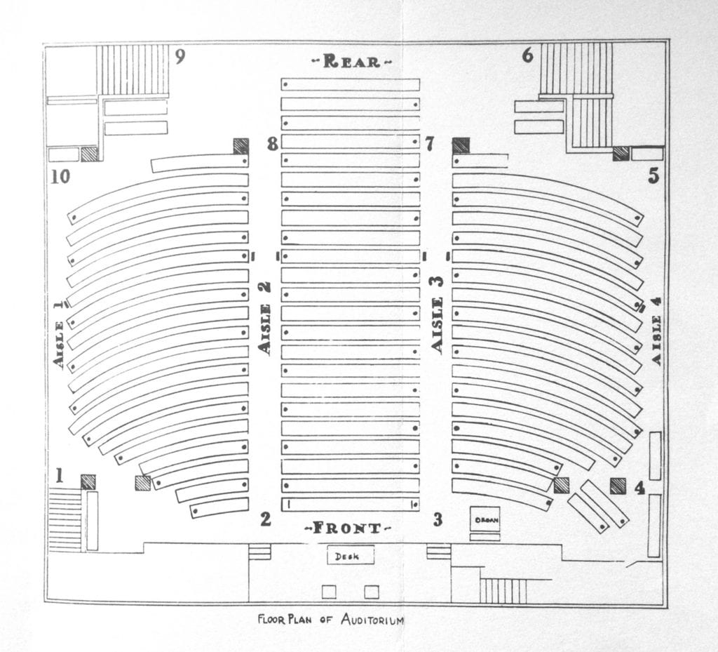
Floor Plan of Auditorium, as originally furnished with seating for 860


The Third Church auditorium was originally designed to seat 860, although there were concerns that it would not be large enough to accommodate continuing growth. Upon moving into the new building in 1922, the church started holding a second Sunday service in the evening, a schedule that continued for decades. By the 1940s, the foyer level was filled with folding chairs for overflow seating, and the church decided to help fund a new church building in nearby eastern Green Lake. The approach of cooperative financial support between the area Christian Science churches, of which Third Church was beneficiary in 1929, continued through the Great Depression and for several decades after, paying off church mortgages one by one and enabling church building in nearly every district in Seattle, even during the most difficult economic conditions. At the peak of the movement in the 1960s, there were 16 Churches of Christ, Scientist, Seattle. Once the need for church edifices was met, they continued cooperative building for the Christian Science Organization on University Way, a nursing facility, and the Christian Science Pavilion at the 1962 World’s Fair.

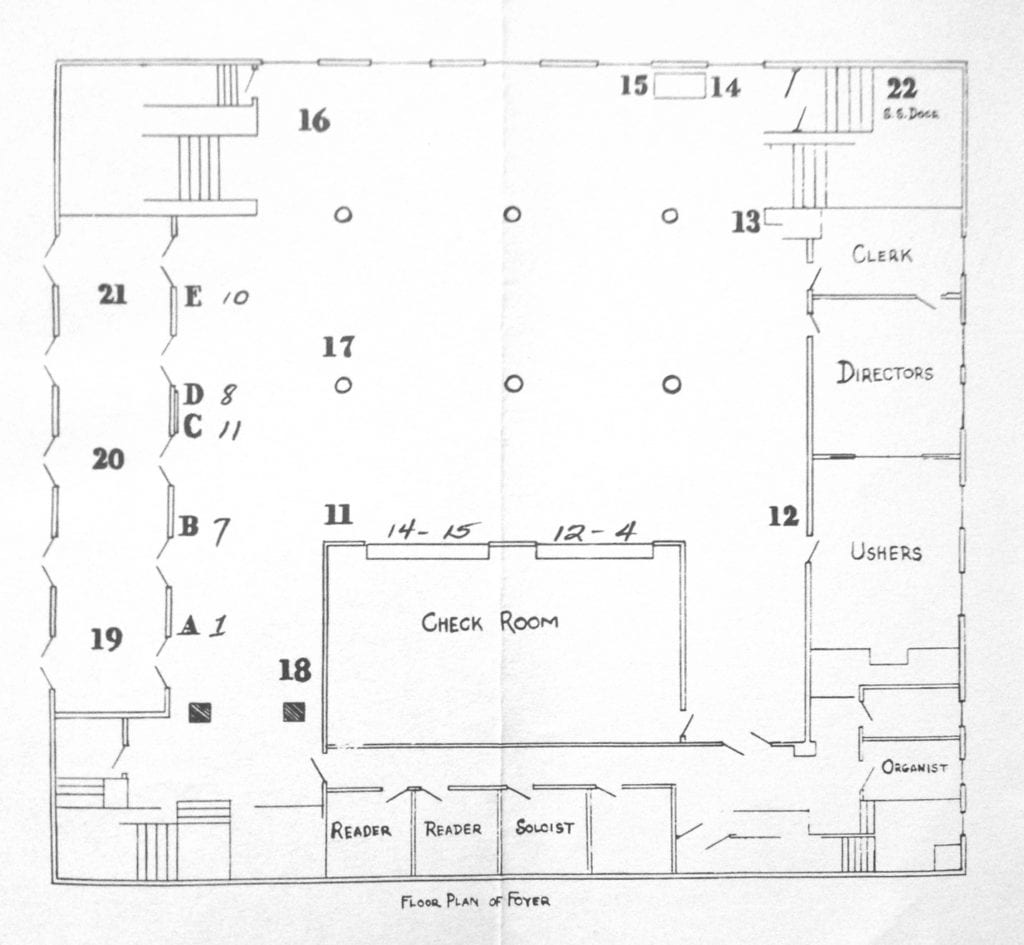
Like the Fourth Church building, the Third Church foyer fills most of the main floor of the building, allowing the entire assembly to mingle after meetings. (Photo: Dale Lang)


The foyer level as it was originally, showing usher stations by number. Churchome has converted the Reader and Soloist offices into additional bathrooms.

Several generations of Christian Scientists grew up attending Sunday School in the basement level of this building and socializing in the large foyer after services. In the late twentieth century – along with churches of nearly every denomination – the population of the Christian Science church declined and no longer needed so many large edifices. The story of Third Church’s 2005 decision to sell its building was told in detail in the May 2007 issue of Seattle Metropolitan magazine, with Kathryn Robinson’s article “Cross Purposes” portraying Third Church as exemplifying global trends in the religious landscape, representative of the U-District, Seattle, and other communities throughout the country.

The entire membership body of Third Church was involved in deciding which purchase offer to accept. They democratically selected an offer that would preserve the building by converting it to an event venue for lectures, similar to Town Hall Seattle. In a last-minute turn of events that surprised even the members of Third Church, however, the building went to City Church, now known as Churchome. Churchome did many of the same building improvements that an arts and civics organization would have: new carpets, fresh paint, theater lights in the auditorium, an expanded stage, and additional bathrooms. Listing the building for sale in April 2020, it now seems Churchome no longer needs the property. The Third Church building needs a new owner, ideally one who will preserve it for future generations.

Christian Science churches are known to be well-suited for reuse, in part because of their lack of religious symbolism. In Seattle, nearly all the edifices originally built as Christian Science churches still stand. Some have been landmarked, including First Church on Capitol Hill (now luxury condominiums), Sixth Church in West Seattle (now an event venue), and Seventh Church on Queen Anne Hill (now Church of Christ). Eleventh Church, the Green Lake church that took the 1940s overflow from Third Church, is now owned by a Taiwanese Christian church. Dunham’s designs in particular have proved adaptable. Besides Fourth Church’s conversion to Town Hall Seattle, Dunham’s edifice in Victoria, British Columbia, still owned by First Church of Christ, Scientist, Victoria, doubles as a community event venue. His edifice in Spokane, Second Church, is now owned by Holy Temple Church of God.

It is sometimes said of old buildings, somewhat remorsefully, “if only these walls could speak,” as though the decades of events that took place inside and around them are unknowable to us today. But in the case of Third Church, its historic happenings are beginning to be heard in detail all around the world. Its well-documented, colorful, and important story is unfolding through narrative nonfiction podcast and book. As a representative of a significant global movement, including establishing women’s rights and gender equality in religion, the building stands as a monument to progress. Regardless of the building’s future, its legacy will be shared with the world. For a preservation-minded owner, the building’s emerging fame could enable fundraising efforts to potentially draw on supporters far beyond Seattle.

Cindy Safronoff is an independent scholar who has presented her research on the history of the Christian Science movement in Seattle at academic conferences in Taiwan and Italy. Her previous book, Crossing Swords: Mary Baker Eddy vs. Victoria Claflin Woodhull and the Battle for the Soul of Marriage, won ten book awards and was featured in the Sunday Boston Globe. Her newest book, Dedication: Building the Seattle Branches of Mary Baker Eddy’s Church, A Centennial Story – Part 1: 1889 to 1929, has been recently released. The audio version is available now as a podcast, “Dedication: A Centennial Story.”

Note: A demolition permit was filed by Churchome in May 2020, pending review by the City of Seattle. Sale was pending in August 2020 but the property is back on the market as of this writing.

Additional reading: “Another Old Church Building on the Edge of Demise,” Clair Enlow, postalley.org, July 22, 2020.

Cal Anderson Park: The Park Behind CHAZ/CHOP

By Taha Ebrahimi

The following is the final in a series of guest blog posts submitted by members of the Historic Seattle community. The views and opinions expressed in guest posts are those of the authors and do not necessarily reflect the positions of Historic Seattle.

These days it seems the whole state of Washington (and sometimes even the president of the United States!) has eyes on historic Cal Anderson Park, an unassuming patch of public green space located in the Seattle neighborhood of Capitol Hill. Only one block wide and three blocks long, these cherished 7 acres have been in service to the public since 1897 when the city purchased the land to construct its first hydraulic water pump. Cal Anderson was designated a City of Seattle landmark in 1999 and is making history again today. On June 8, 2020, protesters calling for racial justice and an end to police brutality occupied the park and declared it part of the Capitol Hill Autonomous Zone or “CHAZ” (later changed to the Capitol Hill Occupied Protest or “CHOP”). The following is a history of Cal Anderson Park told through images comparing the past to the present.

Cal Anderson Park northeast entrance (CHOP tents seen beyond), June 2020. Image courtesy of author.

One of CHOP’s early demands was the return of land to the indigenous Duwamish people. Up until the 1850s the area that Cal Anderson Park sits on today went largely unchanged, used by indigenous peoples for hunting. In 1855, German immigrant John H. Nagle (pronounced “Nail”) settled on Donation Land Claim No. 233 located in today’s Capitol Hill. Nagle had arrived in Seattle just two years prior when the federal census counted a white population of 170 including 111 white men over the age of 21 who were U.S. citizens eligible to vote in King County. Nagle had been living in the U.S. since age 3, but he was not listed in that 1853 King County census and would not have been eligible to vote until he lived in Seattle for at least six months. Nagle was a bachelor who raised cows and cultivated vegetables and fruit trees on Land Claim No. 233. He also helped found the city’s first church (Methodist Episcopal) in 1854 and served as King County Assessor from 1857 to 1861. In 1874, he was deemed “dangerous” and committed to the newly-constructed Washington Hospital for the Insane at Fort Steilacoom. Nagle would spend the remaining 22 years of his life institutionalized before dying at the age of 66 because of “exhaustion due to acute mania.” Meanwhile, the City of Seattle was looking for land to build a reservoir that would prevent another disaster like the Great Seattle Fire of 1889 and, upon Nagle’s death in 1897, the City decided to purchase his remaining acres of land for this sole purpose. The cost was $10,800.

The Seattle P-I wrote in 1898, “In a little hollow which has been a noxious marsh for several years lie four acres of land which are to be a park. They lie on the Nagle tract. Eight or nine feet of surface dirt will be applied, thus extinguishing the marsh. The surface will be adorned with the usual accompaniments of a public pleasure ground.”

Below is one of the earliest known photographs of the land that became Cal Anderson Park, taken in 1899 when construction of the reservoir began. The view looks northward from where the Oddfellows Building is today on the corner of Pine Street and 10th Ave. On the horizon, one can see the twin tudor-style peaks of Pontius School which later became Lowell Elementary School.

In 1901, just at the turn of the century when Capitol Hill got its official name, the city’s water department announced completion of a low-service 21-million-gallon reservoir and the city’s first hydraulic pumping station, the linchpin in the city’s elaborate municipal water system sourced from the 20-mile Cedar River Pipeline in the Cascade mountains. They named it Lincoln Reservoir and the land to its south would be reserved to develop into a public space called Lincoln Park (present-day Cal Anderson Park). In preparation for the Alaska-Yukon-Pacific (A-Y-P) Exposition celebrating the ten-year anniversary of the Klondike Gold Rush. In 1903, the city council contracted with the famed landscape architecture firm of the Olmsted Brothers of Brookline, Massachusetts (descendents of Frederick Law Olmsted Sr. who was best known for designing New York’s Central Park). The Olmsteds were to plan a Seattle park system and design the A-Y-P fairgrounds, as well as develop many of the city’s parks – one of which was the tract of land reserved to be Lincoln Park. In preparation for the influx of 3.7 million visitors expected for the exposition, the city wanted to put its best face forward. Up until then, the city only had Denny Park (a cemetery converted into a park in 1883).

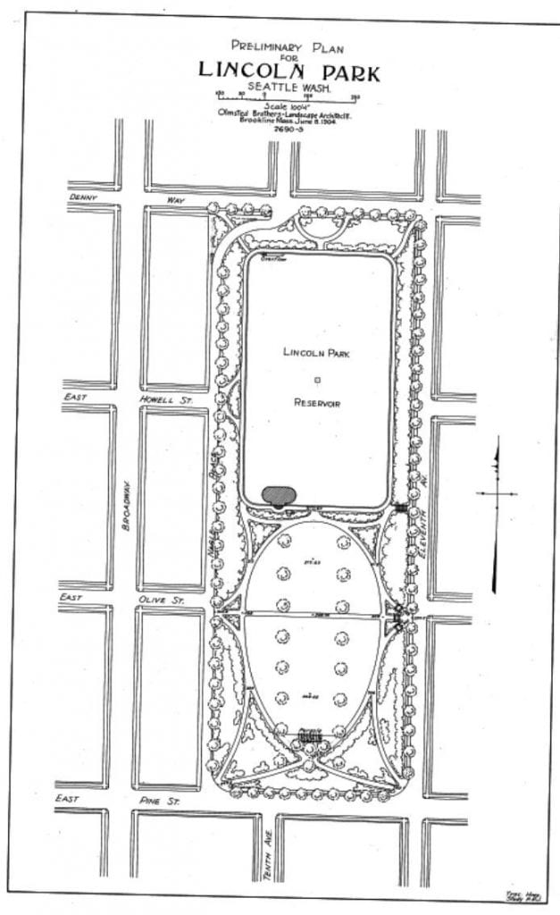
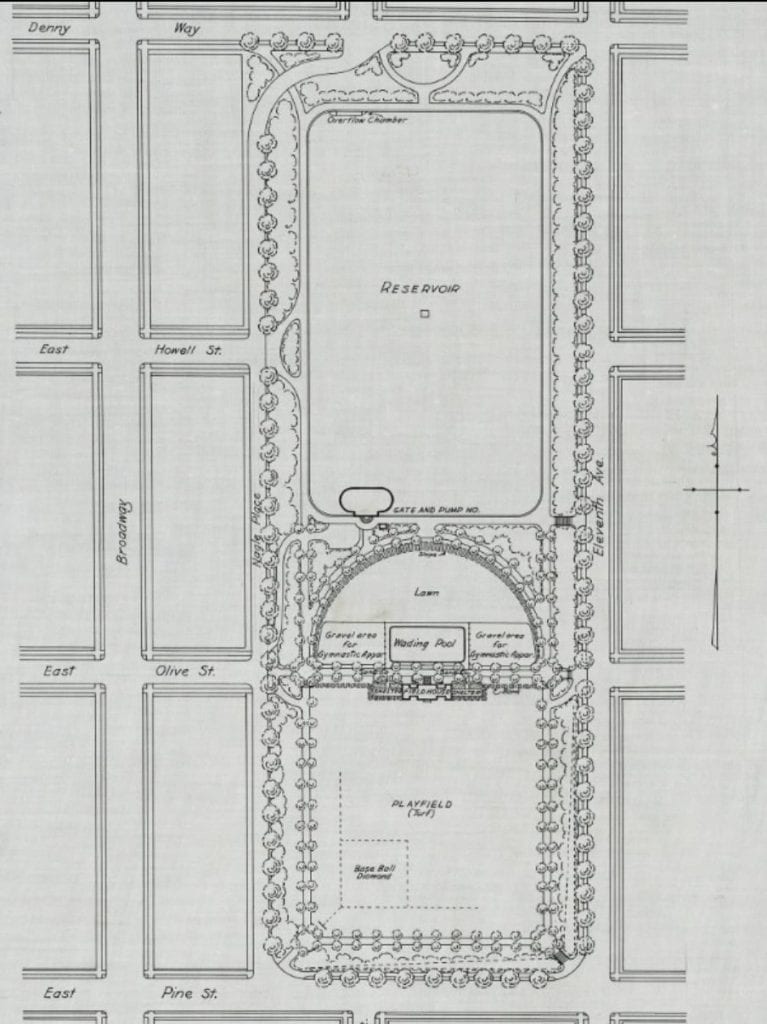
Initially, the 1904 preliminary plan for Lincoln Park (below) included only walking paths and ornamental plantings but no sports facilities. The Olmsteds received feedback that an informal playfield children had appropriated to the south of the reservoir absolutely needed to be retained. Like Nagle in 1855 (and even the protesters of 2020), the children had simply taken over the dirt plot. The city was successfully influenced by this organic “occupation” and a second revised proposal was drawn up (also below) that included a real fenced baseball field at the southern end and a crescent-shaped span that included a wading pool and shelterhouse area devoted entirely to recreation. The original shelterhouse remained until 1962.

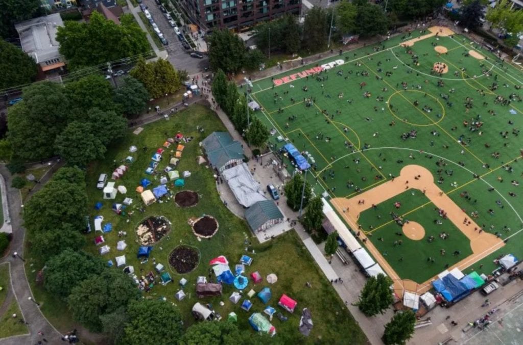
In 2020, the same ballfield demanded by the children of early 1900s Seattle is where CHOP protesters gravitated to occupy again. The central crescent-shaped area near the shelterhouse has been populated by a small village of occupier tents, and the area where the original wading pool existed has been converted into several circular guerilla community gardens (image below).

Aerial view of Cal Anderson Park. June 12, 2020. Image courtesy of David Ryder/Polaris; All Rights Reserved.

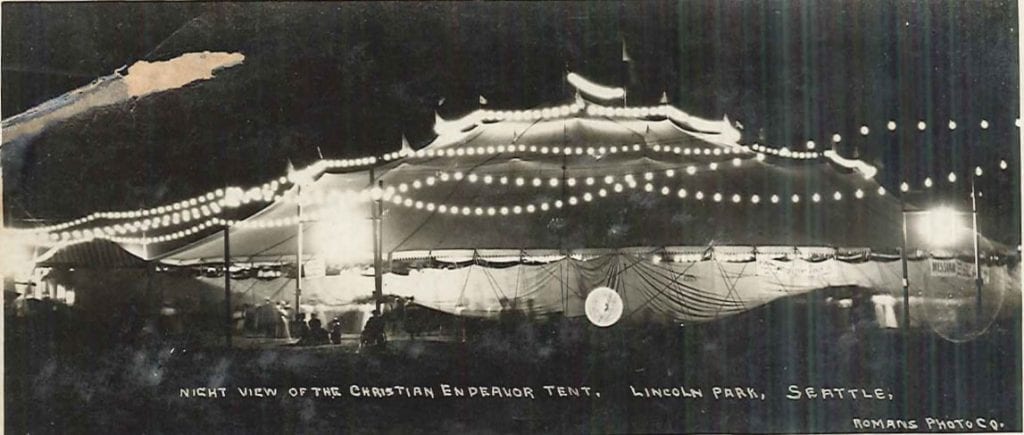
Cal Anderson actually has a history with tents! While the park was being built, the City of Seattle erected a giant canvas tent over the field so that Broadway High School students (what was Broadway High is now the Broadway Performance Hall on the corner of Pine Street and Broadway) could use it for gymnastics in all seasons, regardless of rain. However, the first use of the canvas structure was by the Christian Endeavor for a 3,000-person convention held in July 1907 (image below).

Christian Endeavor tent in Lincoln Park, Seattle, Washington, circa 1907.
Image courtesy of Seattle Municipal Archives, Postcard collection (Record Series 9901-01).

Between 1900 and 1910, Seattle’s population tripled. The public couldn’t wait for the park to be completed so the city installed a cinder running track around the reservoir to tide them over. The following image is from 1906 looking southward from present-day E. Denny Way and Nagle Place. To the left of the 90-foot geyser, one can see Central Lutheran Church of the Holy Trinity on the corner of present-day Olive St. and 11th Ave., a frame building opened only three years earlier in 1903 (and which still exists today). The original stone gatehouse that housed the prized hydraulic pump can be seen on the right.

Lincoln Park Reservoir postcard. 1906. Image from author’s personal vintage postcard collection.

In 2005, the reservoir was covered and replaced with grassy lawns and wrought-iron lamp-lined walkways, as well as a water feature. Below is a view in June 2020 with the fountain turned off due to COVID-19 pandemic-related health restrictions.

Cal Anderson Park gatehouse, June 2020. Image courtesy of author.

The park was completed in time for the 1909 A-Y-P Exposition, becoming Seattle’s first supervised playfield, following a trend of public parks opening across America. The following year, it hosted Seattle’s first “Inter-Playground Athletic Meet” for over 100 schoolchildren and 1,500 spectators (the event is pictured below with children waving American flags and spectators holding umbrellas and watching from 11th Ave. Central Lutheran Church is in the background to the left).

The baseball and football fields turned out to be so popular that teams had to schedule a game ten days in advance. The image below from 1911 roughly shows the same view of the park as the first image in this article, Nagle Place is to the left with Pine Street on the lower right. The reservoir gatehouse and geyser can be seen at the far end and Central Lutheran is to the right. The baseball diamond is where protesters in 2020 would set up their encampment 110 years later.

Broadway Playfield, from southwest corner Pine Street and Nagle Place about 1911. Image courtesy of Seattle Municipal Archives, Don Sherwood Parks History Collection. Identifier: 38023.

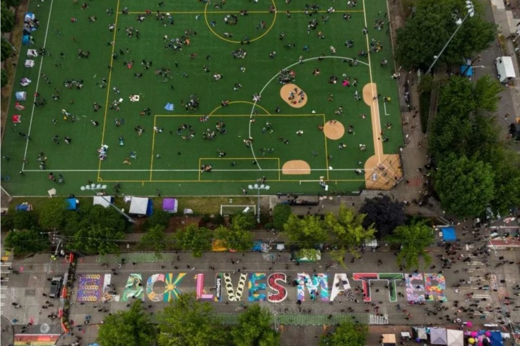
In 2020, Pine Street was the main thoroughfare in which protesters were dispersed by police and National Guardsmen armed with chemical agents, flash-bang devices, and rubber bullets. Following a lengthy standoff, the precinct left the premises and protesters occupied the area, painting “Black Lives Matter” across the width of Pine Street on the southern border of Cal Anderson.

Aerial view of Cal Anderson Park. June 12, 2020. Image courtesy of David Ryder/Polaris; All Rights Reserved.

Back in the early 1900s, the park quickly became a natural gathering place for events. Pictured below in 1912, spectators watch “modern woodmen” drills on the playfield, facing northwesterly with the shelterhouse at the top right and the line of buildings at left on present-day Nagle Place.

Modern woodmen drills, Lincoln Park playground (Now Cal Anderson Park), Seattle, 1912. Image via Pinterest.

The below image is roughly the same view of the playfield in 2020 when CHOP occupied the baseball field (the line of buildings at left are on Nagle Place, and the new shelterhouse can be seen at right).

Bobby Morris Playfield at Cal Anderson Park, June 2020. Image courtesy of author.

Much like the CHAZ-turned-CHOP, the park has also contended with naming issues. In 1922, to avoid confusion with another Lincoln Park in West Seattle, the recreation area was renamed “Broadway Playfield” (the playfield would be re-named again in 1980 to “Bobby Morris Playfield” to honor a local graduate of Broadway High that served as president of the Seattle Chapter of the National Football Foundation). The entire park would be named Cal Anderson Park in 2005 to honor Washington’s first openly gay state legislator, who died of AIDS in 1995. 

By the Great Depression, the Works Progress Administration (WPA) found many opportunities to put men to work improving the public space. In 1932, tennis courts were added, and in 1938 and 1939, the wading pool was replaced and new fencing, football field turf, and outdoor electric lighting were installed. Pictured below in 1938, men can be seen working at the park, facing east. Central Lutheran Church can be seen to the right and, to the left on 11th Ave., one can see the spire of present-day Calvary Chapel which was known in 1906 as First German Congregational Church and offered services for immigrants entirely in German until the two World Wars when German-speaking people were viewed with suspicion and services were curtailed.

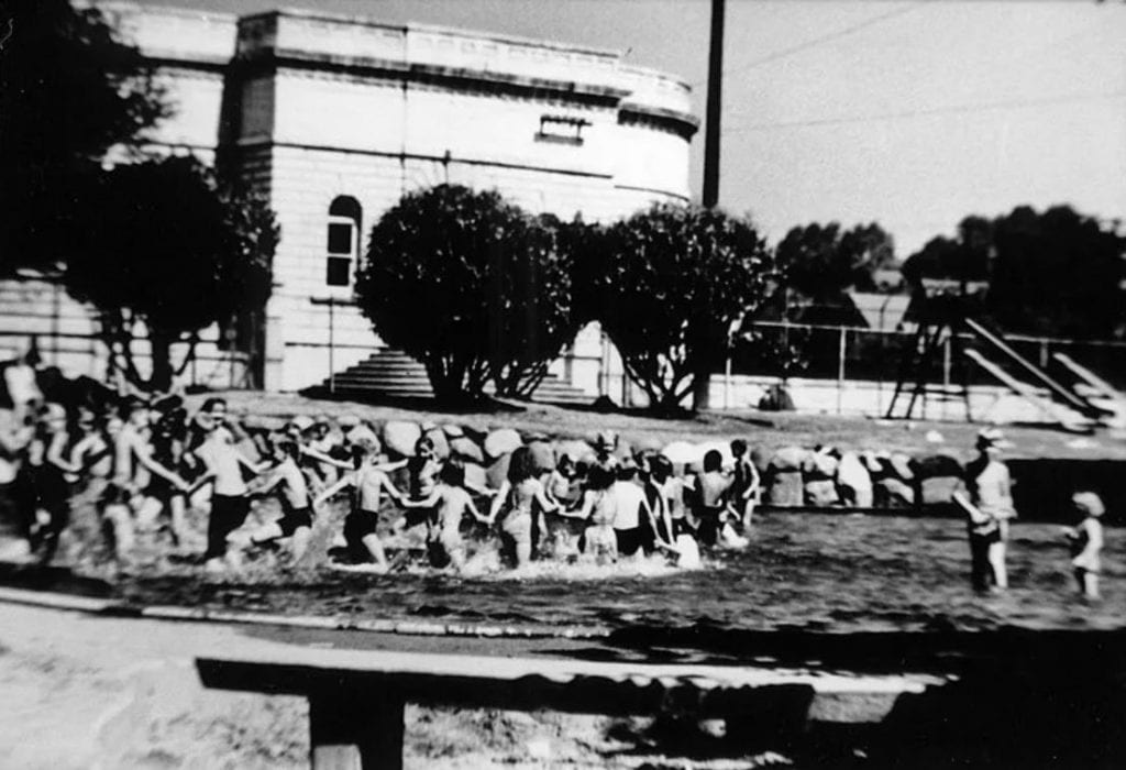
Pictured below in 1950 are the neighborhood’s children swimming in the much beloved wading pool south of the reservoir gatehouse. Just two years earlier in 1948, the U.S. Supreme Court ruled that racially restrictive covenants were unenforceable (since 1924, over 500 racially restrictive covenants and deed restrictions were written in Seattle alone, with Capitol Hill’s restrictions ultimately covering 183 blocks. In 1948, most of the covenants in Capitol Hill were up for renewal but a petition to extend them failed, with one local resident writing he could not “be party to deprive any one of their rights”). Even though the city established its first integrated municipal pool in 1944 (Colman Pool, coincidentally in West Seattle’s Lincoln Park), as one can see from the image below, informal segregation still occurred. It was not until the assassination of Dr. Martin Luther King in 1968 and the resulting unrest in the Central District that an open housing ordinance was passed in Seattle.

The same wading pool still exists today (pictured below empty in June 2020 due to COVID-19 pandemic-related health restrictions).
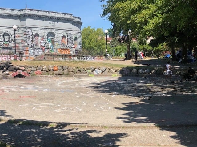
Cal Anderson Park wading pool, June 2020. Image courtesy of author.

The park descended into a decades-long period of disrepair beginning in the 1960s. Kay Rood, a neighborhood local and community park activist pivotal in the rebuilding of the park, recounted her impression of it in 1993: “The park looked like a prison yard from an old black and white movie, with rusted double fencing, a cinder sports field, a small rundown playground, an ugly and dangerous brick restroom building often covered with graffiti, and a semi-permanent population of transients and druggies dotting the landscape.”

Rood along with a neighborhood coalition known as Groundswell Off Broadway began working with the city to advocate for improvements to the park beginning in 1996 when they secured “10 new World’s Fair benches appropriate to an Olmsted park, and 25 new trash containers to replace the beat-up metal cans chained to trees.” They succeeded in getting the park designated as a City of Seattle landmark in 1999. In 2003, a new shelterhouse was dedicated and the park’s new name was unveiled, just as work began on burying the reservoir in an underground vault (the first of Seattle’s reservoirs to be covered). The reservoir replacement and new water feature were completed in 2005. Landscaping was developed to honor the original Olmsted vision, including walking paths lined by historic lighting fixtures and a recreated parapet wall describing the historic reservoir’s perimeter. Once again, the park became a local attraction. 

In 2016, the Capitol Hill station of Link light rail was opened on the northwest corner of the park at Nagle Place. Special attention was paid to preserve the Chinese Scholar tree (sophora japonica) on the corner, which was designated a Seattle Heritage Tree in 2003 and was most likely originally planted by the Olmsted firm. Several very old cherry trees that were also removed from the area to clear way for the station may have been from the original orchard cultivated by John H. Nagle more than 150 years ago.

Cal Anderson Park continues to bear witness to key moments in the city’s history today, acting both as a crossroads and a destination. Once Seattle’s central beating life source for water, this public area remains a canvas reflecting the city’s evolving identity and needs. Every day at the park during the CHOP era seems to be different, and the future is yet unknown, but each generation shares one thing in common: an inexplicable draw to gather and converge here.

Taha Ebrahimi was born and raised in Seattle, and happens to live across the street from Cal Anderson Park.

SOURCES

  1. “Attractive Parks and Pleasure Grounds Where All Seattle Rambles At Will,” The Seattle Post-Intelligencer, December 18, 1898, pg. 28.
  2. Berger, Knute. “Seattle’s Ugly Past: Segregation in Our Neighborhoods,” Seattle Magazine, March 2013.
  3. DeCoster, Dotty. “Nagle, John H. (1830-1897),” History Link.org, January 23, 2010, Essay 9268.
  4. James, Diana E. “Shared Walls: Seattle Apartment Buildings, 1900-1939” McFarland & Co: 2012.
  5. Olmsted Brothers. “Letter from Olmsted Brothers to Mr. Charles W. Saunders.” Seattle Municipal Archives, Don Sherwood Parks History Collection, Item 5801_01_53_04_004 (Record Series 5801-01).
  6. “Racial Restrictive Covenants,” University of Washington Seattle Civil Rights & Labor History Project.
  7. Rood, Kay. “Creating Cal Anderson Park,” History Link.org, January 7, 2006, Essay 7603.
  8. Williams, David B. “Olmsted Parks in Seattle,” History Link.org, June 10, 1999, Essay 1124.
  9. Williams, Jacqueline B. “The Hill With A Future: Seattle’s Capitol Hill 1900-1946” CPK Ink: 2001.
Stimson-Green Carriage House Lives On As Birch Road Cellar

By Ryan Donaldson

The following is the sixth in a series of guest blog posts submitted by members of the Historic Seattle community. The views and opinions expressed in guest posts are those of the authors and do not necessarily reflect the positions of Historic Seattle.

If you have an idea for a future post, please send a draft to info@historicseattle.org. You can review the guidelines here.

Collectively I’d walked by the Stimson-Green Carriage House hundreds of times, never stepping foot inside.The neighboring namesake mansion’s signature English Tudor Revival-style high-pitched roof, pronounced chimneys, dramatic gables, stained glass windows, and half-timbering overshadowed the smaller matching carriage house tucked behind it. Scaling up and down First Hill for my high school commute to O’Dea, the building blended in with the more substantial landmark next door.

As a teenager in 1990s Seattle, there was little chance of getting a peek inside the imposing mansion or carriage house unless you were invited to a wedding or special event. Located at the corner of Minor Avenue and Seneca Street, the mansion served as home to lumber magnate C.D. (Charles Douglas) Stimson’s family at the turn of the century when First Hill was known as an exclusive enclave for the city’s “first families.” The crest of the hill where the Stimson-Green Mansion stands was in the company of over 40 prominent homes that dominated the steep slope, including the Dearborn House (1907, Historic Seattle’s home today) and the W.D. Hofius House (1902, until recently the home of the Roman Catholic Archbishop).

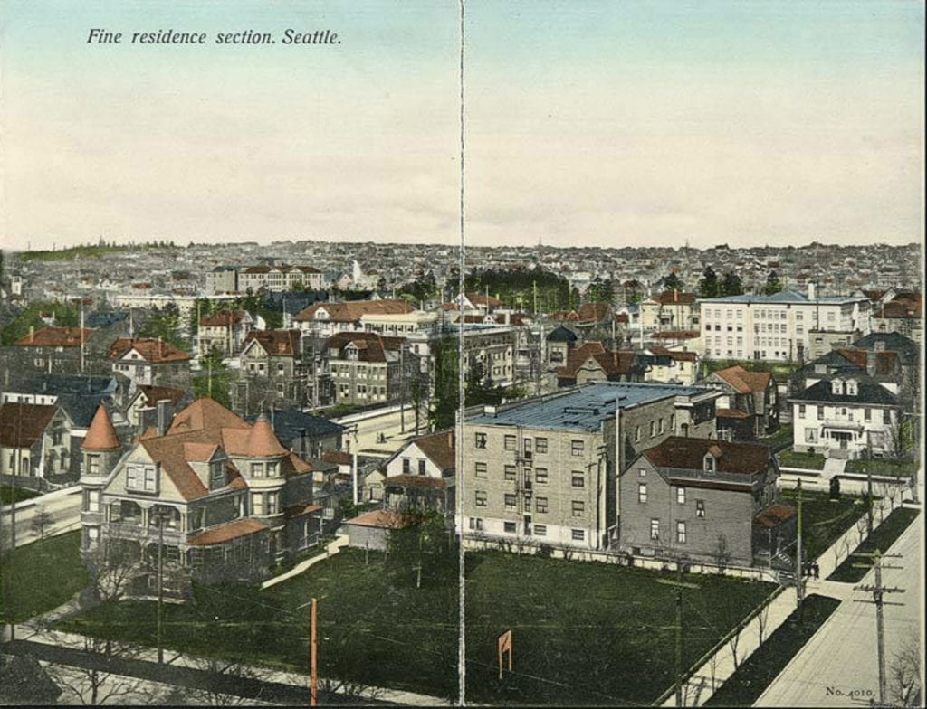
A hundred years prior, the multitude of mansions lining First Hill were the result of fortunes made from timber resources, real estate, and other emerging industries, which led to the commissioning and creation of fashionable residences in a variety of eclectic architectural styles. As noted on a period postcard, First Hill was known as Seattle’s “[f]ine residence section” offering widescreen views of Elliott Bay and within walking distance from Seattle’s bustling downtown. A public exhibit, “The First Hill Exhibit: Seattle’s Boom Years, 1880-1925,” permanently on display in Swedish Hospital’s lobby at the corner of Boren Avenue and Madison Street (incidentally also the site of the former 1884 Carkeek Mansion), vividly illustrates what the neighborhood was like, replete with cable cars and ornate residential architecture.

Panorama of First Hill, n.d. University of Washington Libraries, Special Collections, SEA1910.

Stimson himself had come to Seattle in 1888, drawn by the abundant natural timber resources that had already been depleted in Michigan where his father had first attained the family’s legacy in lumber milling businesses in the mid-nineteenth century. Setting up operations in Ballard to take advantage of the increased demand for lumber after the Great Seattle Fire of 1889, Stimson quickly came to city prominence, also serving as director of the Metropolitan Building Company, Metropolitan Bank, General Insurance Company of America, and the Alaska-Yukon-Pacific Exposition. It took two years for Spokane-based architect Kirtland Cutter to complete the building, which the family moved into in 1901. Stimson, his wife Harriet Overton Stimson and their two children Thomas Stimson and Dorothy Stimson Bullitt, began living in the stately residence before any landscaping or tree cover, the land having only recently been cleared of its original growth Douglas fir trees.

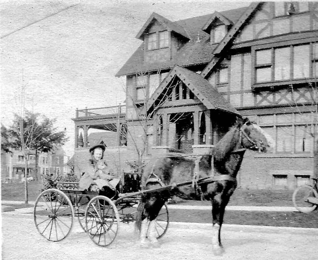
Stimson’s mansion included a two-story standalone carriage house just north of the main estate, a common form of outbuilding purpose-built for horses and carriage equipment. In one particular historic photo, we can see Stimson’s young daughter Dorothy with her pony, Doctor, on Minor Avenue.

Dorothy Stimson Bullitt on her pony cart with Doctor. Courtesy the Washington Trust for Historic Preservation.

Later, when horses gave way to automobiles, the Stimsons expanded the carriage house to its present 2,000 square foot size for their fleet. “Doctor had one corner [of the carriage house] and a little red Autocar (model 1900) had another,” recalled Dorothy. “Over the ensuing years, the car models changed, but not the pony. We had a cow, too. There’s a little back door in the garage that opens onto the alley and that’s where the cow lived.” 1

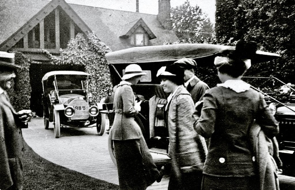
C.D. Stimson (on far left) greets an unidentified group in front of his carriage house, ca. 1910. Image courtesy Washington Trust for Historic Preservation.

In 1915, a year after the Stimson family moved to a larger home in The Highlands, Joshua and Laura (Turner) Green acquired the property. Joshua Green’s business was in the steamboat and ferry industry, which evolved into the Washington State Ferry System. What is remarkable was how little of the mansion and carriage house was changed or altered during the Greens’ 60 years of ownership. In contrast, the surrounding neighborhood was quickly transforming. Apartment buildings and medical facilities rapidly replaced the mansions as the “first” families moved away. For the Greens’ carriage house, rather than be torn down or radically remodeled as was the fate of other carriage homes, the building remained as an automobile garage, even retaining its original back alley door, though the cow was long gone.

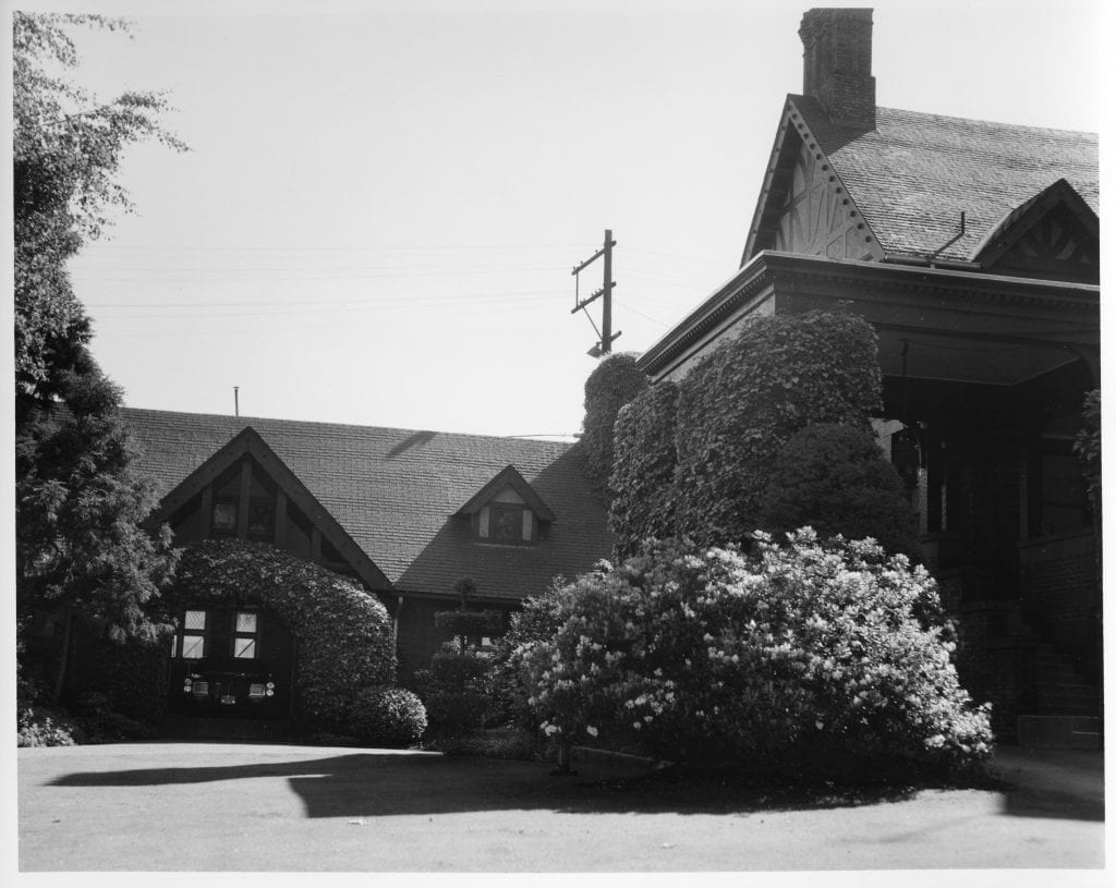
View of the carriage house in 1969 which includes a car facing out from the garage door. Image courtesy Seattle Municipal Archives, Identifier: 78250.

In 1975, following Joshua Green’s death at 105 years old, the Historic Seattle Preservation and Development Authority purchased the property, which included both the mansion and the adjoining carriage house. The site was then acquired by Priscilla (Patsy) Collins (C.D. and Harriet Stimson’s granddaughter), and the mansion was reopened for the public to enjoy.2 No longer a private residence, mansion programming in the following years included behind-the-scenes tours, weddings catered by in-house staff, theatre performances, and other special events. In the late 1970s, the carriage house was converted to offices and housed a series of tenants, including the Bullitt Foundation – the nonprofit conservation organization founded by the adult Dorothy Stimson Bullitt.

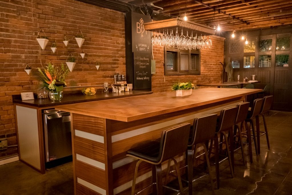
Since 2001, the site has been owned and managed by the Washington Trust for Historic Preservation. In 2016, the Trust oversaw the carriage house’s renovation, which included polishing the concrete floors and exposing the open beam ceiling and brick walls. Soon thereafter, the Chicago-based Birch Road Cellar leased the carriage house with a vision to build community through providing space for members to entertain guests outside of their homes, securely store spirits and wine in a climate-controlled cellar in a self-service environment, as well as utilize co-working space (members pay a monthly fee for the opportunity to work and host guests in the well-appointed space). Opened in May 2019, the major tenant improvements to the carriage house transformed the raw space into the stunning interiors that can be seen today.

View of remodeled self-service bar. Image courtesy Birch Road Cellar.

When I first heard about this new chapter for the carriage house, I happened to be seeking a new co-working space and quickly scheduled a visit. Several decades after those walks past the landmark in my high school days, I finally stepped foot inside. I was not disappointed: Upon walking in the door and being warmly greeted by co-founder Sharon Provins, I immediately knew this was the right place for me. I admired the historical elements and the adaptive reuse of the space, providing inspiration for my working environment. There was no question the building was once a carriage house. In the upstairs bathroom you can still see the hay door next to the toilet (don’t worry, the door is now welded shut).

After becoming a member and enjoying the space as if it were my own, what surprised me was how quickly I felt connected to the Birch Road community. I recall the photo of C.D. Stimson over 100 years ago, cigar in hand, sharing a mirthful moment with visitors outside in front of the carriage house – and it occurred to me that one of my favorite things was welcoming guests for the first time too. I was not expecting to make friends and form bonds with other members, but have since been delighted to meet both newcomers to the area (like the Stimsons once were) to those who had grown up in Seattle like myself. We all had something in common because we were drawn to the same storied space.

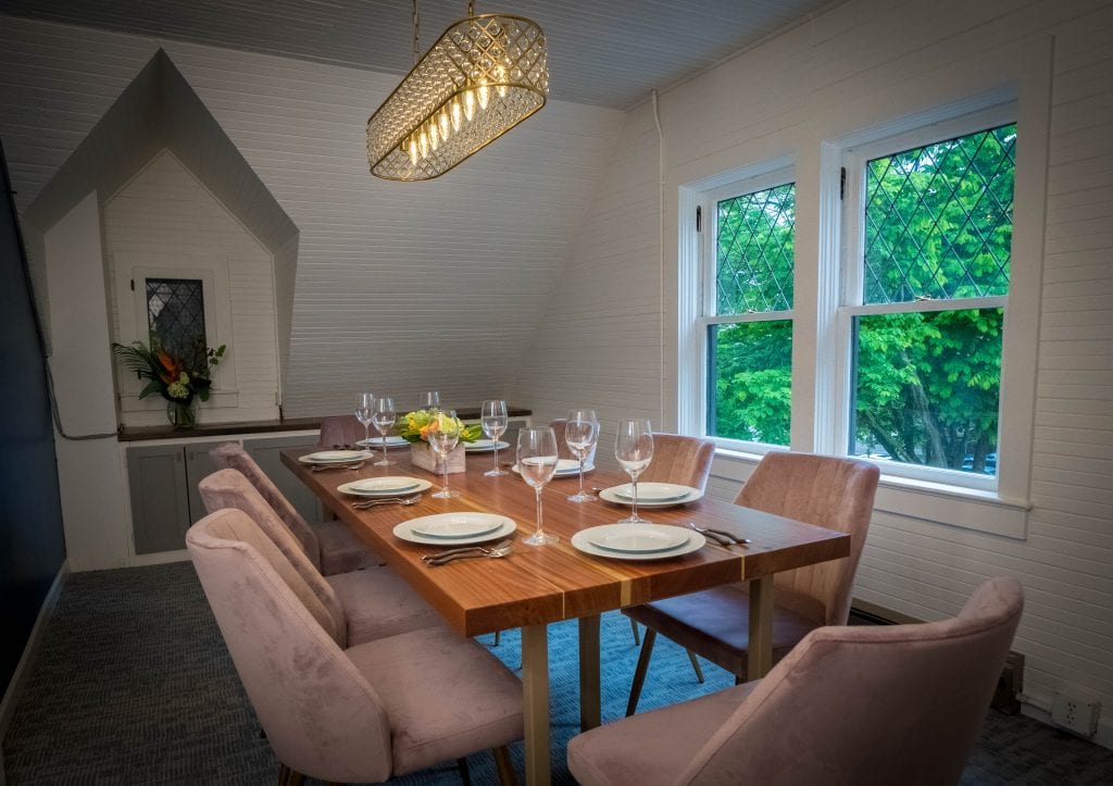
Upstairs meeting & dining room with view overlooking First Hill Park, currently under renovation. Reservations for the room can be made by members online. Image courtesy Birch Road Cellar.

As Washington State’s “Stay At Home, Stay Healthy” order remains in place, Birch Road Cellar will begin a pilot reopening program in June. To keep the members engaged, the club has offered virtual events, such as trivia nights, cooking classes and wine tastings, though I can’t wait to visit again in person. The Stimson-Green Mansion and Carriage House share the opportunity to be accessible to new audiences and to be recognized as places that matter, especially to those like myself who ventured by many times in the past and wondered what was inside. First Hill has other examples of creative collaborations that have helped to preserve the quality of our historic spaces, including the Museum of Museums, the Sorrento Hotel, and St. James Cathedral. It is a tradition that I hope will continue, as innovative partnerships between historical preservationists and private capital will become increasingly necessary approaches in the bid to honor and cherish our city’s past.

Ryan Anthony Donaldson is a cultural heritage strategist, digital asset manager, and archives consultant. Ryan currently works as Senior Consultant with The Winthrop Group and Collections Strategy Manager & Archivist with the Washington State Jewish Historical Society

Serendipity or Perseverance

By Ana Lena Melka

The following is the fifth in a series of guest blog posts submitted by members of the Historic Seattle community. The views and opinions expressed in guest posts are those of the authors and do not necessarily reflect the positions of Historic Seattle.

If you have an idea for a future post, please send a draft to info@historicseattle.org. You can review the guidelines here.

In October 2004, after months of negotiations, we finally closed on the 1914 mansion that my husband had fallen in love with earlier that year. After more than a year of house hunting across the Puget Sound region, we happened to walk past what looked like a haunted house in the Capitol Hill neighborhood and my husband said, “Now, if that house was for sale, I’d sell my soul to buy it!” A day or two later he discovered that it was for sale, which is where our journey (obsession?) began!

We made an appointment to see the house and immediately realized it would need a tremendous amount of work, not just on the outside, but also on the inside. At least it had a good roof! There would be electrical work, plumbing, windows, tile, plaster wall repair, new heating, floors to refinish, even stolen fixtures to recover over the next year and a half. One of the few things that we just could not find was tile to replace the broken ones on the front porch. Our master tile craftsman suggested we tear it all up and salvage what we could. He would then install a different tile in the middle, and use the old tile to do a border. But we didn’t even know what kind of tile it was! We consulted experts who insisted it was slate – it delaminated on cleave lines the way slate does. We even had a man stop by who said he could get us slate to match – just a complete stranger who happened see us working – so we hung onto that hope for a couple of years!
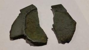
So many other things were going on that we just shelved that project, while keeping our eyes and ears open to the possibility of finding the right material. One of the rabbit holes I went down was making the rounds of all the tile stores in the greater Seattle area, taking my little pieces of tile with me in hopes someone would have a matching product, or even just tell me what material they were made of. Historic Seattle hosted a tile lecture at Rejuvenation and of course I signed up with the hope of finding the answers to the tile question.

In 2014, we thought we finally had a match: quarry tile, made in Spokane. Sadly, it was not to be, as the manufacturer did not do custom matches and their samples were not a match for our tiles. At that point we began to think that doing the carpet tile inlay was our only option.
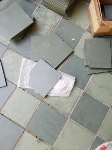
We had subscribed to Old House Journal through the years and at the end of 2015 I reached out to Patricia Poorer about help with identifying our tile. She wrote back to say they were “pretty sure” it was slate, so I contacted Sheldon Slate. No match again!

Another year went by and while reading Old House Journal I came across an article about Willapa Bay Tile in Ocean Park, Washington. I contacted the owner, Reneé O’Connor, to see if she would be able to make us some matching tiles. She wrote back with some exciting information: Tile Heritage in California was the place we had been looking for all these years!

Introductions were made online and we sent them samples. At last, a definitive answer! What we had was indeed manufactured tile, not slate. Best of all, they identified a vendor able to do a custom match: American Restoration Tile in Little Rock, Arkansas.

Bryan Byrd at American Restoration Tile assured me that they could match the size and color of our tile and gave us a proposal. We were so excited to move forward after all this time when another obstacle appeared. Sadly, Mr. Byrd passed away. Fortunately for us, his family had decided to keep the company operating – so we sent larger samples for color matching.

But, of course, it still wasn’t smooth sailing! Our master tiler had retired, and the craftsman we had found to replace him was not available to do the installation when the custom tile arrived. So, I just took the boxes to the basement unopened until he was available. Rookie mistake!

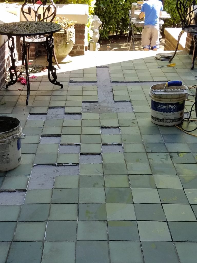
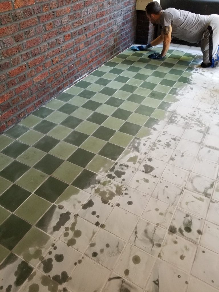
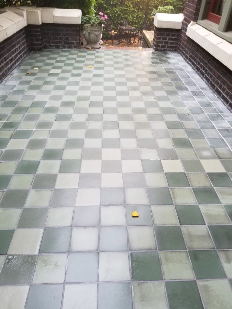
May 15, 2018—the day was finally here for tile to be laid. Opening the boxes revealed a bunch of broken tiles! So much time had gone by, it was too late to file a claim with the shipper. But the wonderful people at Tile Heritage were so gracious, they sent replacements and we were able to get the job done. Well, almost done – we had to wait for the additional tile to be manufactured and shipped. The tiler installed all he could, and when the new batch came he finished the job and grouted the whole area to match. Looking at our porch now, it’s hard to remember how it looked for all those years. But that’s what pictures are for!
Ana Lena Melka, originally from Mexico, has made the greater Seattle area her home since 1973. She considers herself a local non-native species! She and her husband, Mark Mayhle, bought the Shafer Baillie Mansion in 2004 and opened it as a bed and breakfast in 2006 after restoring and updating it. Mark is a Seattle native who was born at Swedish Hospital and would rather live here than any other place!

See All the People: Mt. Virgin Church Changes with the Times

By Eleanor Boba

The following is the fourth in a series of guest blog posts submitted by members of the Historic Seattle community. The views and opinions expressed in guest posts are those of the authors and do not necessarily reflect the positions of Historic Seattle.

If you have an idea for a future post, please send a draft to info@historicseattle.org. You can review the guidelines here.

Here Is the Church

It started with a small wooden church on a hill between the Rainier Valley and Seattle’s Central District named for the patron saint of Germany. St. Boniface was built, probably sometime in the 1890s, by and for German Catholic immigrants to the city who hoped to worship in their own language.

Information on the little German church is scarce. The 1901 and 1902 Seattle Polk Directories list “St. Bonifacius, German Roman Catholic” at 28th Avenue South and Massachusetts, along with the words “no services.” Later additions of the directory make no mention of the church at all. The 1912 Baist map show the church alone on the hillside except for a small house immediately to the north. Anecdotal evidence indicates that a succession of caretaker families lived in the basement of the church, some German-speaking, some Italian.

The Italian Transformation

By 1910, the area surrounding St. Boniface was made up largely of Italian immigrant families – so much so that the area was nicknamed “Garlic Gulch” – and thus the little church was the natural choice for an Italian parish. Seattle Bishop Edward John O’Dea called on the Jesuits to minister to the growing Italian community in the city. On September 10, 1911, Fr. DeRop, S.J. said the first mass in Italian at the church. The diary of the Jesuit order notes that two weeks later Fr. DeRop took “some of our old pews” to the new Italian church. About this time the church’s name was changed to Our Lady of Monte Virgene, after a well-known church in Caserta, Italy. A sketch rendered by University of Washington graduate student Nellie Roe in 1914 depicts the church and school surrounded by a fenced garden. The caption states that “102 Italian children” attend the school.

In 1913 Fr. Lodovico Caramello arrived to take over for the ailing Fr. DeRop and immediately began to fast track plans for a new, grander edifice in the Florentine style of his homeland. The fruition of this project in 1915 is credited largely to Fr. Caramello’s commanding personality and his contacts in his native Italy.

The Italians built their church just to the west of, and back-to-back with, the old German church. The 1916 Sanborn map shows “Mt. Virgin R.C. Church” almost touching the “Old Church.” The small house is labeled “School,” although it was also the parish rectory. With the tower removed, St. Boniface became the parish hall and later served in a number of capacities, including as a gym, kindergarten, and workshop, before ultimately being torn down about 1970. Army surplus buildings, placed on the church property in the 1940s, became the Mount Virgin School where local children received instruction from Irish Dominican nuns and sometimes from the priests themselves.

For several decades, Mount Virgin and Father Caramello were the heart of the Italian community in Seattle. Long-time resident Ralph Vacca recalled:

The church in the Italian community, at least in that generation, was the center. And Father Caramello was God in America. You could take a string or measuring stick and go out whatever distance from Mount Virgin Church and there would be a lot of Italian names and families.

Vincent LaSalle spoke of the Italian culture that defined the church:

I was raised in the Catholic school with the Dominican nuns, Mount Virgin, the little Italian parish. And I became an altar boy when I was only in about the fourth grade and Father Caramello says he’s “gonna make an altar boy out of me.” So I became an altar boy; I was number one! And you never seen anything like it – such beautiful boys! You know the altar boys at the end of the year, they used to have a great big party, you know, all the Italian kids. They were all Italian, all of them.

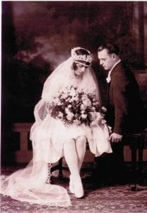
Vacca-Patricelli wedding, 1927. Courtesy of the Rainier Valley Historical Society

To this day Our Lady of Mount Virgin is designated as a “national parish,” one without traditional geographic boundaries. Specifically it was, and is, an “Italian National Parish,” one of several in the country created to serve a specific immigrant community.

Opening the Doors

In the last decades of the 20th century, the Italian population in Garlic Gulch began to disperse, pushed out by the I-90/Mount Baker tunnel projects and changing demographics. Many Italian-Americans had already moved out to the suburbs by the time the second major freeway expansion began in 1979. Attendance at mass dwindled steadily and there were fears the church might close altogether. However, in that same year the first of several waves of Laotian Catholic refugees arrived in the Rainier Valley. Assisted by an Italian Catholic group working with the tribal people of Laos, these refugees were adopted into the parish, bringing new life to the little church.

Mount Virgin also has a special relationship with Native American Catholics in Seattle. For a number of years the parish offered a special mass for Native Americans. Today it continues to reach out to immigrant communities, particularly Laotian, Chinese, and Vietnamese communities, while still honoring its Italian origin. During the current Covid-19 crisis, no masses are scheduled, although the church is open for quiet contemplation during specified hours. It is located at 1531 Bradner Place South, just off MLK Jr Way, in the shadow of the Mount Baker lid.

Things have changed for Mount Virgin, but there is hope for the future as the church embraces the Catholic tradition of “adopting and adapting” to new circumstances and cultures.

Information for this story is drawn from the archives of the Seattle Archdiocese, Special Collections at the University of Washington, Puget Sound Branch of the Washington State Archives, and oral histories collected by the Rainier Valley Historical Society.


Eleanor Boba is a public historian who writes about historic places off the beaten path at Remnants of our Past. A stint at the Rainier Valley Historical Society gave her a deep appreciation of Southeast Seattle.

The Regrade Disasters

By Michael Herschensohn

The following is the third in a series of guest blog posts submitted by members of the Historic Seattle community. The views and opinions expressed in guest posts are those of the authors and do not necessarily reflect the positions of Historic Seattle.

If you have an idea for a future post, please send a draft to info@historicseattle.org. You can review the guidelines here.

Between 1929 and 1930, a wee bit of Queen Anne (that part east of 5th Ave. N., west of 9th Ave. N. and bound by Denny Way on the south and Broad St. on the north) got washed into Elliott Bay as part of the third Denny Regrade. Our bit formed the northeast corner of the project. The lowering of Denny Park, the city’s first park, was a big part of the work even though purists will say the park isn’t in Queen Anne at all!

I’ve known that for a very long time and ever since I moved back to Seattle in 1985, I’ve wondered why. Stumbling on a paper written some 42 years ago, I discovered the reason. Having returned in my first old age at age 36 to graduate school to study historic preservation planning and architectural history, I took Seattle as the subject of many assignments. After all, I had just spent four years teaching at the UW, so Seattle history became my go to topic.

R.H. Thomson, courtesy of Paul Dorpat

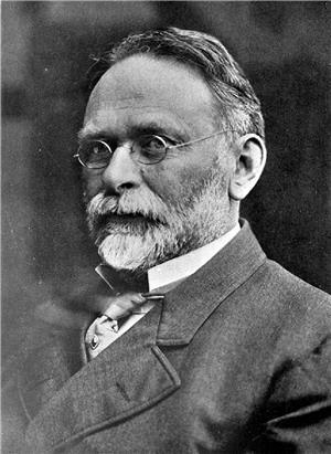
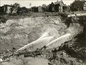
I prepared that paper (“The Denny Regrade”) for a class in the history of American urban planning with the dean of the field, Professor John C. Reps. My paper traced the history of the regrade projects. The first one took place between 1898 and 1899 when city engineer Reginald Heber Thomson (1856-1949). convinced city officials to remove a portion of the hill on the north end of Seattle’s downtown. Thomson had been the city engineer for nearly a decade when the project began. He was obsessed with fostering the city’s economic growth and sure that expanding the business district out of the pit in which he saw it trapped would help the city grow. Thomson defined the pit as the land between the mud flats south of Yesler Way and Denny Hill.

Washing the hill away, courtesy of the Seattle Public Library

The first regrade washed away First Avenue from Pine Street to Denny Way. The second regrade (1903-1911) took down Denny Hill from Second Avenue to Fifth between Pike and Cedar.  The third one occurred between 1928 and 1930 as a nutty response to the second one after it failed to increase land values or attract the energy of the burgeoning central business district. Some say Thomson was a visionary. I see him in the same class as robber barons, those stubborn autocrats set on getting their way whatever the consequences. I forgive Thomson because his bull-headed behavior was well intended and didn’t make him rich. To be perfectly fair, Thomson had nothing to do with the third regrade. He’d moved on long before it began.

Hydraulic sluicing Seattle’s soft clay made the regrade projects easy to do. The sluices were, by the way, a common strategy for moving wet earth and were part of Seattle’s culture following the Klondike Gold Rush where stream beds were diverted through sluices to strain them for gold. By the time of the third regrade, the work got easy. Rubber conveyor belts moved the washed-out dirt to Elliott Bay where cleverly designed barges dumped it. Filled with dirt falling from the belt, the double-sided barges were towed out in the bay where they flipped over, dumped their loads and presented an empty bin ready for refilling at the shore.

The Denny Hotel in 1903, courtesy of Paul Dorpat

It seems fair to say that except for dumping tons of dirt into Elliott Bay and leveling a very big hill, the regrades flopped terribly. They did practically nothing to improve the economic vitality of the city until almost a century later when Amazon finally redeveloped that big chunk of the third regrade between 6th and 8th avenues. It is Thomson’s failure to see the possibility of the regrades failing economically that interests me.

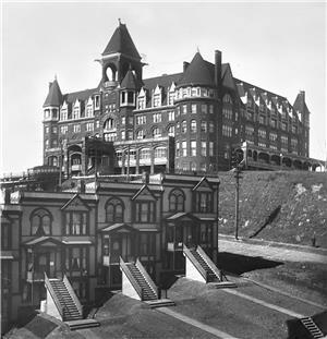
The first regrade set the stage for the second. James Moore, owner of the huge Washington Hotel on top of Denny Hill, resisted the regrade concept that Thomson touted. Moore had bought the unfinished Denny Hotel at the tippy top of the hill from Arthur Denny, renamed it the Washington Hotel and completed it at considerable expense.

The Washington Hotel on Denny Hill after the first regrade, courtesy of MOHAI

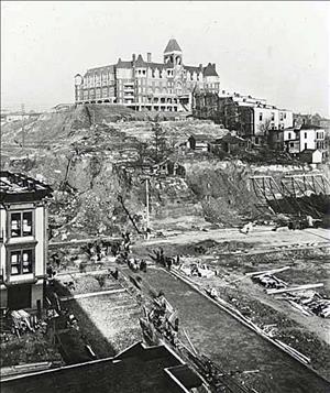
Moore balked at tearing down his hotel and his substantial portion of the hill, but Thomson charged ahead with the first regrade making Moore’s hotel pretty inaccessible. When Moore caved in, Thomson moved forward with the second regrade. The top of the hill and the hotel began to disappear in 1906. About the same time, Moore built a new hotel, the New Washington, at Second and Stewart (today’s Josephinum) and the Moore Theatre next door. Both were completed in advance of the 1909 Alaska-Yukon-Pacific Exposition, the world’s fair held on the UW campus.

Stretching roughly from First Avenue east to Fifth and from Pike north to Cedar, the second regrade leveled about 170 feet of Denny Hill. For comparison purposes, it stood a little bit more than one third as high as Queen Anne Hill (436 feet) today. As Walt Crowley tells it, the failure of the first regrade was driven partially by being butted up to the second half which provided a dismal backdrop to the new flatlands of Belltown. Crowley also points to two other factors that stymied the redevelopment of the regrades. Both can be attributed to poor thinking by Thomson or his arrogance.

Crowley politely contends that Thomson could not have anticipated the advent of the automobile which made close in development of the city less necessary and that he had no way to understand the impact of skyscrapers such as the Smith Tower (completed in 1914). Skyscrapers increased the density of offices in the historic core and like the automobile reduced the need to expand over the land.

I’d agree that Thomson’s timing was off, but skyscrapers were already dotting New York and Chicago. Seattle got its first skyscraper, the Alaska Building, in 1904, just about the time of the second regrade, the big one, got underway. Were he the far-thinking urban planner local historians have seen in him, he would have understood the future of very tall buildings. Maybe his rural Ohio roots blinded him to this urban potential. As for the automobile, Crowley may be right. There were only a couple of thousand cars in the state when the second regrade began. The automobile was still very far from its polluting heyday, and no one could have anticipated its impact on urban sprawl. In fact, we still haven’t figured out how to manage it.

The system embraced for financing the regrades may have been the final nail in the coffin. To finance the work, the city adopted a local improvement district, a LID, just like the one recently imposed on downtown businesses to fund improvements along the waterfront. Property owners in the regrades were taxed to pay for the work under the assumption that the improvements, the lowering of the hills, would increase property values and make them rich.

It just didn’t work out that way. The new flat land of the second regrade was unnecessary and ugly. Without the need for fancy stores, homes or hotels in the new neighborhood, flop houses, bars and some tenements moved in. At the very same time Paris and New York were identifying unhealthy neighborhoods for their ultimate removal, Seattle built one.

Thomson tried to remedy the problem with the second regrade by washing the hill he’d left behind into the bay. The outcome was nearly as bad. The flop houses, bars and single room only apartments only spread. Eliminating the eastern portion of hill gave license to the down and out character of the first regrade to spread unchecked. My guess is that Prohibition didn’t hurt either.

The third regrade completed between 1928 and late 1930 eliminated what remained of the hill. Eventually, the bulk of it was bought up by the Clise family, Seattle’s most well-known real estate developers. As late as 2008, the Clise property was the largest contiguous inner-city tract of land in the United States, larger even than New York City’s 22-acre Rockefeller Center.

Now, long after I wrote that paper for John Reps, I worry about the people in government making unchallenged decisions that are transforming our world. At the end of 19th c., Thomson convinced city officials to undertake a project that transformed Seattle. Until Amazon’s recent purchase of broad swaths of the third Denny Regrade, the northern portions of Seattle’s business district were a disaster, lying fallow for over 100 years. In reviewing my paper, my fear of simply accepting the wisdom of people in power is confirmed. Of course, Thomson did some great things for Seattle, particularly the Cedar River watershed project which still provides our clean drinking water, but he garnered too much power. His biggest ideas went unchallenged, and some, such as the Denny Regrades, bore rotten fruit.


Michael Herschensohn trained in architectural history and preservation planning at Cornell University. He served on the Historic Seattle Council for nearly 30 years. Michael continues volunteer preservation work as president of the Queen Anne Historical Society where he regularly writes about the fabric of his neighborhood’s built environment. This piece originally appeared on the QAHS website.

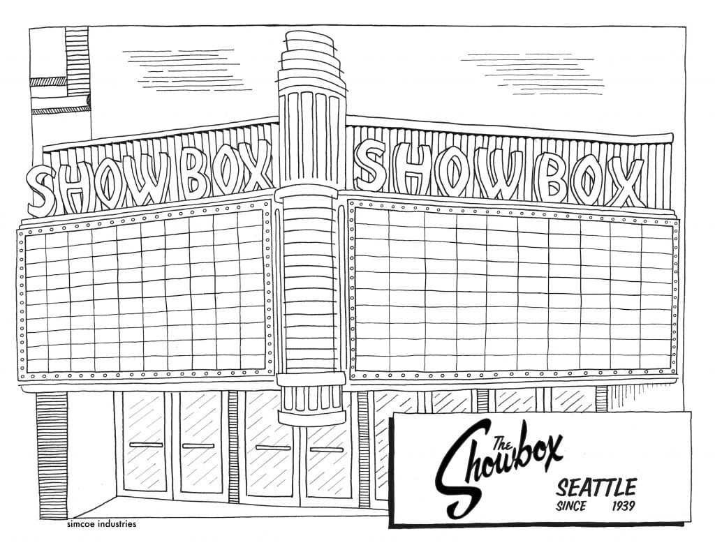
Color Your Own Showbox Marquee!

Are you looking for something fun to do while staying safe indoors? Robb Hamilton of Simcoe Industries has shared a copy of his original pen and ink drawing of The Showbox for you to print and color yourself. You can even write your own message in the marquee!

We can’t wait to see what you create – tag us in a Facebook or Instagram post, and don’t forget to use the hashtag #savetheshowbox. You can also email your completed marquee to us at info@historicseattle.org! Read on to learn about how Robb got started drawing old signs of Seattle.

The following is the second in a series of guest blog posts submitted by members of the Historic Seattle community. The views and opinions expressed in guest posts are those of the authors and do not necessarily reflect the positions of Historic Seattle.

If you have an idea for a future post, please send a draft to info@historicseattle.org. You can review the guidelines here.

By Robb Hamilton

After the Four Seas in the International District closed a few years ago, I made a pen and ink drawing of the sign for my brother as it was the spot where he met his friends before and after Seahawks games. It elicited such a positive reaction that I started to draw more old signs from Seattle, including Art’s Plaza, Ying’s, and Imperial Lanes. Although none of these signs were architecturally or historically significant, they were treasured by people who grew up in the city for the memories they invoked.

When I learned that Historic Seattle was involved in trying to save The Showbox, I got the idea to make a poster of the original Showbox marquee which I could sell to raise funds for the preservation effort. I’ve seen tons of shows at The Showbox and the thought of losing it bothers me greatly. Just as my brother had a strong emotional tie to the Four Seas, lots of folks in Seattle have similar reactions to The Showbox.

Since we all need activities to keep us busy during quarantine, here is a copy of my original pen and ink drawing. Feel free to color in the neon tubes and letters and write your favorite show on the marquee (my fav was Screaming Trees).

Click the image below to download and print the PDF:

Robb Hamilton is an illustrator from Seattle. He likes drawing old signs. Simcoe Industries is named after the Simcoe Mountains in Klickitat County where his grandparents lived.